The Railways - The Strzelecki Line
is part of the GSR
Part of the Great Southern Railway the Strzelecki Railway Line was a 49 km steam-era branch railway line in Victoria, Australia.
The line opened in June 1922, branching off the former Great Southern Railway (South Gippsland line) at Koo Wee Rup Station. The main line branched off the current Pakenham line at Dandenong, extending out into the South Gippsland region and ran to Port Albert.
- Read also below -
Opening and description
The Strzelecki line opened on 29 June 1922, serving the farms of the Strzelecki Ranges. Sheep and/or cattle loading facilities were provided at all stations except Heath Hill, with goods loading and storage facilities at all stations except Athlone.
Two years after the line opened, two goods sidings, situated between Koo Wee Rup and Bayles, were provided: Plowrights siding and Water Washed Sand siding. Narrow-gauge tramlines ran from both sidings to the main Koo Wee Rup drain, and were used for transporting river-washed sand to the main line. Both Plowrights and Water Washed Sand sidings closed in 1931.
Bayles - was the first station on the line, situated in light scrub just south of the township. From Bayles to Catani the line ran on the north side of the canal. You can see the alignment readily enough, but that is about all.
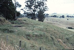
Catani - was the next station - now a mound of earth remains where the platform was.
The station was opened on 29 June 1922, and closed on 15 April 1950 along with Yannathan station, when the line was truncated to Bayles station leaving it the only remaining station on the Strzelecki line until it too was closed on 4 February 1959.
Yannathan - platform was 11.5 km from Koo Wee Rup, and
Heath Hill - was a further 2.4 km along the line.
Athlone Quarry Siding, 94.14 km from Koo Wee Rup, was opened with the line, but closed three years later.
Athlone - The station was 2.4 km further along the line, followed by Topiram.
Topiram - The station was opened on 29 June 1922, and was closed on 7 August 1941 following flooding of the Lang Lang River, which resulted in damage to one of the four trestle bridges over the river, after which the line was closed back to Yannathan station.
Upon opening of the line in 1922 Topiram station was supplied with cattle and sheep yards, goods loading and storage facilities, and passenger facilities.
Triholm - 106.6 km from the junction, became the terminus of the line after the section beyond was closed on 22 November 1930. Beyond Triholm, the line featured steep grades and sharp curves.
After Strzelecki station's closure, no other station on the line was supplied with a turntable, requiring trains to run tender-first in the down direction and returning to Koo Wee Rup engine-first. There was also loco facilities at Koo-Wee-Rup.
From Koo-wee-rup to Heath Hill, the line ran across the reclaimed Koo-wee-rup swamp, and is this is all but dead flat, there is next to nothing in the way of earthworks to see.
History Strzelecki Railway Station.
The former Great Southern Railway (South Gippsland line), which opened in 1892, branched from the Gippsland line at Dandenong and ran to Port Albert.
The Strzelecki railway line, which branched off this line at Koo-Wee-Rup, was opened in June 1922. The line served the farms of the western Strzelecki Ranges, and the stations provided facilities for the storage of goods andthe loading of sheep and cattle. Historic photographs from the 1920s show stockyards next to Strzelecki Station.
Strzelecki was the eighth and last station on the Koo-Wee-Rup to Strzelecki line after (Bayles, Catani, Yannathan, Heath Hill, Athlone, Topiram and Triholm).
Construction of the line came at a time when railway expansion was being curtailed as a result of increasing government expenditure on roads and the development of motor vehicles. But the continued development of this line can be largely attributed to the significant increase in vegetable crops and dairy produce arising from the draining of the Koo-Wee-Rup swamp, which in turn supplied Victoria's profitable overseas trade in perishable foodstuffs.
Strzelecki Station was only 8 km to the East of Triholm but its elevation was almost 200m greater, and 23 cuttings were required between the two.

The station closed on 22nd November 1930, after a timber trestle bridge on the section of line between Triholm and Strzelecki developed a large sway every time a train passed over it - in response to the severe financial difficulties experienced by the Victorian Railways, falling traffic and disrepair of infrastructure, including the bridge at Strzelecki.
The line was closed in sections, the first being Topiram/Strzelecki in 1930 (it only lasted 8 years, before a threatened bridge collapse) and Koo-wee-rup / Bayles in 1959 the last.
The Triholm and Strzelecki (Dismantling) Act, No 4518 of December 1937 authorised the dismantling of the rails and the sale of land.
The track in this section of the line was taken up in 1938, whilst the turntable and station buildings at Strzelecki had all gone by 1940.
The Strzelecki Railway - current state.
About what you can see from the remains of the former Strzelecki Railway.
- Koo-wee-rup - The remains of the old loco area (turntable pit, inspection pit) exist on the down side of the level crossing. The formation towards Bayles can be see curving away.
- Bayles - The station yard is now a fauna sanctuary and there is a $2(?) admission, and probably not much (of railway interest) to see, although I haven't looked. There is a sign, a station nameboard, a (road) weighbridge, and a mile post.
- Catani station - a road was built along the route of the railway embankment leading through. A few trees on an uncharacteristic mound mark the remains of the platform.
A road continues on the formation most of the way to Yannathan. - Heath Hill - There are now buildings on the site of the former station.
From Heath Hill to Triholm the line followed the Lang Lang River, so some earthworks are visible.
From about a mile beyond Heath Hill to Athlone a road parallels or is built on the formation, including through a curved cutting of reasonable size. There are remains of a couple of bridges in this section.
A further trace of the railroad track between Heath Hill and Yannathan is hardly available. - Yannathan - station ground can be discerned by the fences marking the boundary if you know where to look.
- At Topiram - only cattle sheds remain of the entire station.
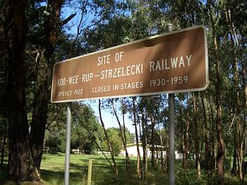
At Athlone and Triholm there are signs commemorating the line. The formation where the line crosses the (current) road is easily visible. - From Triholm to Strzelecki Station the line climbed at 1 in 30 to 1 in 40, and earthworks were extensive. However, apart from a short distance part Triholm and a short distance before Strzelecki Station, most of this is well away from the nearest road and not readily visible.
Just before Strzelecki Station there is the site of a very large trestle, followed by a very deep cutting which was previously crossed by a road bridge. Part of this cutting has been filled by using it as a tip, but enough remains to appreciate it. - From here to Strzelecki Station the line paralleled the main road and is mostly easily seen. There is a metal shed on the station grounds, and the formation continues some distance past the station to the turntable site cut into the side of the hill.
It must have had the best view of any turntable in the state.
Strzelecki Railway Station turntable.
To find the turntable site (pit and concrete abutments exist), have to travel down a gravel road. The turntable site lies on the slope at the head of the valley. It is overgrown by vegetation.
Strzelecki Station was the only station on the line to be fitted with a 53-foot turntable.
Ganger's facilities at the station were the Ganger headquarters, tool shed and departmental residence. Motor gang trolleys were also kept at the station.
A significant are the remains of the Strzelecki motor turntable, which is located in a private area on the east side of Wild Dog Road, a few hundred meters south of the intersection with the Warragul-Korumburra Road.
On below current (2014) view Strzelecki turntable looking away from Station.
 Goods facilities at the station included goods loading platform, goods shed and cattle and sheep yards. Motor gang trolleys were also kept at the station.
In its current state the turntable is a flat circular feature, partially defined by low walls constructed of mass concrete. A shallow cutting on the north side indicates the route of the railway leading to the turntable.
The turntable indicates the role of Strzelecki Railway as the terminus of the line. The significance of the turntable is enhanced by its rarity value as one of the few surviving physical features associated with the railway in South Gippsland Shire.
It has scientific (archaeological) significance for its potential to yield further information about the historic development and use of the Strzelecki Railway station site.
Closures
The Strzelecki Line turned out to be one of the shorter-lived lines in Victoria. The section between Triholm to Strzelecki closed due to a trestle bridge developing a large sway every time a train ran over it, with the cost of repairs deemed uneconomical in view of the light traffic.
The section of track from Yannathan to Triholm was closed on 7 August 1941, after flooding of the Lang Lang River resulted in damage to one of the four trestle bridges over the river.
Next to close was the section from Bayles to Yannathan, on 15 April 1950. The line to Bayles was kept open until 4 February 1959 to serve a butter factory.
The line construction
The line was constructed with 60 lb/yd (29.8 kg/m) 'D' steel rail, using sleepers 8 ft 4 in (2,540 mm) long, 9 in (229 mm) wide and 4 1 / in (114 mm) deep, with nine sleepers being used for every 22 ft 6 in (6.86 m), or 20 sleepers per 45 ft (13.72 m) length of rail, laid on a ballast of sand 6 in (152 mm) deep.
Track speed for passenger and freight services was 25 mph (40 km/h).
A railway turntable or wheelhouse is a device for turning railway rolling stock, usually locomotives, to face a different direction. It is especially used in areas where economic considerations or a lack of sufficient space have served to weigh against the construction of a turnaround wye. |░| Back to Railway Station.